Queensland-based aerospace companies Gilmour Space Technologies and Hypersonix Launch Systems have signed an agreement to…

Fleet Space Technologies to accelerate mineral exploration with launch of GeoSphere
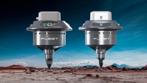
Adelaide-based Fleet Space Technologies has launched GeoSphere, a first-of-its-kind system that combines wireless Geodes, intelligent cloud processing and a constellation of low earth orbit (LEO) nanosatellites to discover critical resources up to 100 times faster than traditional methods.
The GeoSphere systems is a passive, non-destructive technique to assess site viability for mineral and material deposits. It drastically reduces the requirement for current environmentally damaging survey practices such as the use of explosives, noise machines and drilling.
“The IMF predicts that in just two decades more than USD $13trillion-worth of the four major energy transition minerals must be mined to reach net zero ambitions, said Matt Pearson, co-founder of Fleet Space technologies. “This requires more sustainable, faster and economically viable exploration practices. In GeoSphere we have created the answer by unlocking the power of global connectivity through Fleet’s network of small satellites”
These satellites are already in operation in tandem with revolutionary non-invasive probes that rapidly scan beneath the earth to identify sources of these critical resources, he said.
“This removes the need for invasive drilling practices, significantly reduces cost and can speed up discoveries more than one hundred-fold.”
Deposits of copper, nickel, cobalt, gold and lithium for example, which are used to create zero emissions car batteries can now be discovered through a 50 sq/km grid of satellite-enabled Geodes, which can be easily installed by small, local teams. These are hand-transportable sensors which dramatically reduce the logistics requirements for remote exploration projects. It also allows explorers to adapt their approach quickly without the need to dismantle and move heavy equipment.
Each wireless, battery-operated Geode contains a sophisticated processing unit, satellite transmitter and a seismic sensor. The Geodes use the principles of seismology to map the properties of the Earth’s subsurface from reflected seismic waves by recording ambient noise – a process known as Ambient Noise Tomography (ANT).
The processed data is securely pushed to Fleet Space’s existing network of Centauri low-power small satellites. The satellite then automatically sends the information to ground stations, dramatically reducing the time required to process data.
The data from each Geode is rapidly processed through a machine learning algorithm aimed to deliver a full 3D visualisation of the subsurface down to 2 km depth. A clear, rich image of what resources are below ground can be generated in as little as four days – ordinarily, ANT takes 6-12 months to return a conclusive result. Using a bespoke Fleet-developed system, these visualisations are accessible to view and export anywhere on earth in real-time. The speed of this imaging now means that thousands of square kilometres of area can be imaged in a fraction of the time of traditional methods.
Related Posts